On LeConte, there are so many areas to explore in one's free time, and since the sand myrtle prefers to grow on cliff sides and rocky mountain faces, it made sense to wander around those famous points right in my backyard. Bushwacking up the ridge of Cliff Tops may seem daunting, but is a relatively easy climb once you figure it out, and the rewards are commendable. The views from the handful of vistas along the way and the dense patches of myrtle that cling to the cliffs continue to get better as you make your way up. Another great bushwack is to take a path that leads down the face of Cliff Tops, taking one about a third of the way down to the Alum Cave Trail just below. When the cliff itself angles inward to the mountain, you know that means it's time to stop going down, or else bad news bears. There you get views of Cliff Tops from the middle, with rocks, sand myrtle, and rhododendron growing all around you, a change from the typical view one gets up top.
The month of May can be most memorable on the mountain when the mountain myrtle blooms. (How's that for alliteration, all you teachers out there?) Visiting places like Cliff Tops, Myrtle Point for which it is appropriately named, and the connecting trails like Rainbow Falls' Rocky Spur or Alum Cave's Inspiration Point at this time of year makes for quite a scene. Sure, there are great patches of the myrtle in bloom trailside, but you've got to be willing to climb a few rocks and get scratches from tree branches if you want to see the best displays. On LeConte, there are so many areas to explore in one's free time, and since the sand myrtle prefers to grow on cliff sides and rocky mountain faces, it made sense to wander around those famous points right in my backyard. Bushwacking up the ridge of Cliff Tops may seem daunting, but is a relatively easy climb once you figure it out, and the rewards are commendable. The views from the handful of vistas along the way and the dense patches of myrtle that cling to the cliffs continue to get better as you make your way up. Another great bushwack is to take a path that leads down the face of Cliff Tops, taking one about a third of the way down to the Alum Cave Trail just below. When the cliff itself angles inward to the mountain, you know that means it's time to stop going down, or else bad news bears. There you get views of Cliff Tops from the middle, with rocks, sand myrtle, and rhododendron growing all around you, a change from the typical view one gets up top. 
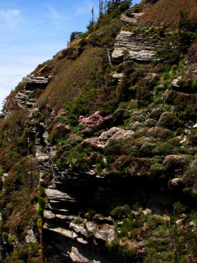
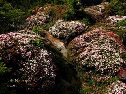
Obviously, Myrtle Point is the place to be. Not many of the bushes around the immediate vicinity of the point are in bloom, mostly do to the erosion of the soil that the bushes like, but a good number produce decent blooms. There are a number of ridges that extend down from the point and run down to meet The Boulevard on opposite sides of the mountain. If you're willing to push your way through the brush on those, you won't be disappointed. Taking the ridge that turns to the north has the best display of sand myrtle you'll see anywhere. The bushes are large and abundant with blooms forming a dense blanket of white, red, and pink. Add to the mix the fact that your on a narrow ridge with great panoramic views of the valley below and the slopes of LeConte. I also discovered this week that the same ridge makes for a great place to watch the sunset, another break from the traditional Cliff Tops. 
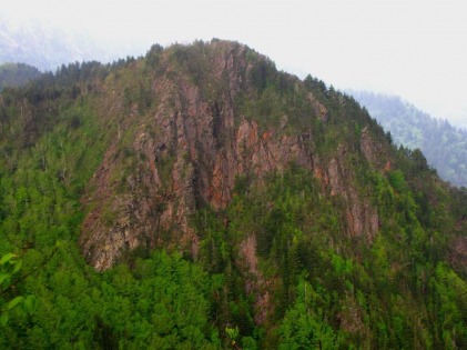
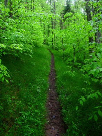
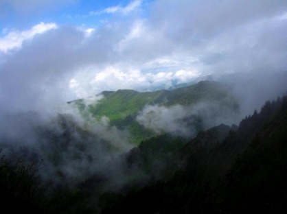
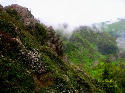
On Monday, I woke up with a ton of energy and ambitious plans for a hike. I had the afternoon to myself and wanted to venture far. Even though the weather was a little sketchy at times, I wouldn't let it bother me, for I just wanted to be out and about. I had been to The Jumpoff before, but wanted to go further this time. Charlies Bunion would add more miles, but I was just there a week ago. Then I thought, aim farther east of the bunion, an area I've only ever seen in the clouds and rain. It was ambitious, but it was just the drive I was looking for that day. All the way across The Boulevard, I was moving in and out of clouds, sunshine, and mists. I was up and over Mount Kephart before I knew it and made it to the bunion in just over an hour and a half. Before I even left for the day's hike, I determined that wherever I was after two hours of hiking, I would stop and turn around to make it back to the lodge in time. So at this point, I pushed eastward along the AT. When I got to the clearing just before Dry Sluice Gap, I had a clear view of the valley to the south that is the Kephart Prong watershed. Past the gap I began to make my way up and over the start of The Sawteeth. Appropriately named because the ridges at this point are jagged like a saw blade and extremely narrow in places, like two or three yards wide with drop offs. The trail was often lined with thick patches of yellow bead lily in full bloom. The views are outstanding on a clear day...something I had never experienced here....until now!!! One can look back along the Smokies main crest and see the steep, scarred slopes of Charlies Bunion and another point which almost looks like a miniature Half-Dome. I remembered seeing the side trail that led the point's summit, so at an hour and fifty minutes in, I decided to turn back early and make my way up to the unheralded vista. As I ascended the rocky trail, it started to sprinkle, but luckily the clouds remained high enough for me to take in the views. The panorama is nearly identical to that of Charlies Bunion...rocky ledges with vertical dropoffs, overlooking the valley into Porters Creek and the spine of the Smokies to the east. A few differences are that you are higher up and instead of sand myrtle there was Catawba Rhododendron in bloom. Another sign that summer is just around the corner. This time I couldn't afford to linger, but I look forward to returning to this great lookout in the near future.
1 Comment
Despite the heavy rains from the previous night, the morning saw breaks in the clouds with a ceiling above the mountains. The forecast called for more rain to develop throughout the day, but there was a window of opportunity to get in a good hike early. Regardless of the weather, I was going to start out at Newfound Gap and complete the loop that takes one down Sweat Heifer Creek Trail, up Grassy Branch and Dry Sluice Gap Trails to Charlies Bunion, and across the AT back to where I began. Usually this is the kind of hike you want to do on a clear day with so many view points along the way. I realized that I might not catch any of them if the clouds stuck around, but also felt that the prospect of completing new trails and seeing different wildflowers would make for a great hike anyways. When I arrived at Newfound Gap, the cloud base had dropped just below 5,000 feet, so I would begin in the coolness of the clouds. I started out wearing my rain gear but quickly shed it when it was making me hot. It's not like I needed it anyways since the only precipitation was the occasional mist which actually felt nice as I made the ascent. When I reached the junction with the Sweat Heifer Creek Trail, I was still in the clouds, although there was jubilation. I had passed by this trail sign countless times, but now I would finally be turning to the right to explore a new path. Since I was doing a loop hike, I could have chosen to take the AT to the bunion first and reverse the ups and downs. At this stage, I figured it was best to get the downhill out of the way while it wasn't raining, and who knew, maybe the clouds would break by the time I reached the bunion. It was a gamble, but it was also my original plan, so I stuck with it. Shortly after leaving the AT one comes to a clearing in the trees where a small bench is situated to soak in the views south into North Carolina. There would be none of the valleys below, just the white wall of the clouds. The trail then made a switchback and quickly dropped. There wasn't a whole lot for wildflowers along the way except for some white erect trillium, toothwort, and foamflower. I received a surprise when I came across a lone pink lady's slipper, the only one for the day. Neat to see one all the way up here and far from the Cades Cove vicinity where they seem to prosper. Further down I came to a point where a chunk of the mountain was missing. Apparently this is where an old roadbed belonging to the Champion Fibre Company cut through the ridge to form a turn. Shortly there after the trail comes to a level area where old rusty parts are scattered around the forest floor. Still continuing the descent, I began to make several stream crossings, one being the Sweat Heifer Creek. The creek was wide and had several cascades as it plummeted down the ravine. This was also the area where I saw the first of the yellow bead lilies and brook lettuce in bloom. On several previous hikes I had only been seeing the leaves and a few buds. Eventually I reached the Kephart Prong Shelter, nestled in a valley next to the creek. It was a good time to have a bite to eat and reenergize before making the ascent to the bunion. When I was here two years prior it was on a rainy day, and this time came under similar circumstances. With several miles ahead of me, I was ready to press on. Now the average hiker might be discouraged by the start of the Grassy Branch Trail. It goes up immediately, and I mean up. Plus one has to traverse two landslides that obviously need some work. No worries, since after that point the trail becomes very pleasant and the ascent passes with ease, despite how it might look on paper. For much of the way, the trail is lined with blackberry brambles and tall grasses; hence, the name. About halfway up, I noticed a few breaks in the clouds where sunlight was penetrating through to the valleys. The upper elevations remained socked in and patches of fog were present down below. Foamflower was still blooming much of the way up, and you could see random sections where tall Norway spruces stood out in the forest, planted by the Champion Fibre Company and never harvested. They are similar to the native red spruce, but possess branches that hang like a weeping willow. The higher I got in elevation, the taller the grasses got that covered the trail, dampening my rain pants above my knees. I can only imagine what this trail would be like in the summer, blackberries included. Once I reached the junction with the Dry Sluice Gap Trail, I was back in the clouds again. Shortly after I made the turn toward the AT it began to mist...and then shower...and then rain heavily. I have only but a few pictures from this portion of the hike since I needed to protect my camera from getting drenched. I was hoping I could have had clear skies at this point because there were several stretches where the trees were open enough for views to the west and probably the backside of the bunion. It was not to be. As soon as I reached the AT at Dry Sluice Gap, I ran into the first person of the day, an older, bearded gentleman thru-hiking his way through the rain. Again, views I should have had to the north were blocked by the white wall. I knew this was the likely scenario, but it would have been nice to have the views. The last time I was out this far was five years ago on a backpacking excursion, in which the weather was the same. Eventually I'll hit it on a clear day. Less than a quarter mile before the bunion, I came to a clearing on the ridge's southern slope. It was surreal because as soon as I stepped out of the woods and into the open the rain ceased, the clouds above formed a hole, and I was offered a view into the valley from which I just ascended. At the same time, three more thru-hikers stopped for a break, also intrigued by the momentary break in the weather. Oddly enough, I reentered the woods on the opposite side and the rain and clouds returned. On my way up to the bunion I had no idea of what to expect other than a white out and wet rocks. What was about to happen I'm not sure can ever be duplicated. As I took the trail that loops around the face of the bunion, I could see but a few feet in front of me. I noticed that sand myrtle trail side were in bloom, so that was a bonus. The clouds were becoming less dense as I went along and I could see further out to the bunion. More of the blooming sand myrtle that clung to the rocky slopes could be seen up and down in colors of white and pink. I was almost to the popular rocky outcrop when the rain ceased and I stopped to remove my rain coat. I stuffed into my backpack, and looked up to an amazing sight. The clouds were beginning to break up and disappear all around. Suddenly I had views into Porters Valley, of green ridges in the distance, various cloud formations, and blue skies above. The trend continued and my heart began to race with excitement. I wasted no time in climbing the bunion to observe what was unfolding right in front of me. The sun was shining brightly, enhancing the fresh spring greenery of the surrounding mountain sides, the cottonlike clouds, and the blue background of the sky. Easily one of the most awe inspiring moments I've ever had in these majestic mountains. The only way to serve the moment justice would be simply to describe it as perfection. It begins with the timing. Imagine if I decided to come out here first and reverse the loop. I would have missed it all. Stepping out of the rain to have the skies clear at this exact location, the sand myrtle all in bloom, and having the entire bunion to myself...I couldn't have even dreamed that one up. Mother Nature sure knows how to work her magic! Shortly after leaving the bunion, the clouds began to thicken and recover the ridges. On my way up Mount Kephart, I passed several hikers who looked dejected from the weather conditions, and here I was all giddy and shaking from what I just witnessed. I tried to explain to them what had happened without rubbing it in their faces, recommending that they have patience when they get there in that the clouds might break again. I would assume they didn't since it began to rain by the time I reached Icewater Spring. These conditions persisted most of the way back to Newfound Gap with occasional rays of sunshine and views into North Carolina. It just amazes me how one moment with such timing made an okay hike into an incredible one. I think I'll be talking about this one for a while to come!
|
Thanks for visiting!I appreciate you stopping by. This site is for your enjoyment as much as it is mine. Look for new photos and journal entries about every 1-2 weeks. Archives
November 2011
Categories
All
|